Homebush Movement and Place Connectivity and Streetscape Upgrade
- Project typeActive Transport Infrastructure

Homebush MaP Project
Strathfield Council is creating more options for active travel in Homebush with a series of improvements to local roads and footpaths to make it easier and safer for pedestrians, motorists and bike riders to travel along The Crescent and through the future Homebush Transport Oriented Development precinct.
What is the Homebush MaP?
The Homebush Movement and Place Connectivity and Streetscape Upgrade project aims to deliver 2.7km of new walking and cycling infrastructure to enhance links to key local destinations including Powell’s Creek walking and bike path, Homebush Village, Homebush Station and the Airey Park Bay-To-Bay Run. A report outlining a revised design was presented to Council at its meeting on Tuesday 25 March 2025. After careful consideration, Council resolved to proceed with delivery by staging works, subject to appropriate grant funding being available.
View Council Minutes
Council will provide updates on the release of detailed design and procurement documentation as it becomes available. It is anticipated that we will commence construction mid 2025.

Select a Section of the Homebush MaP for more project information.
Section 1: Airey Park to Bridge Road
Summary
Section 1 of the Homebush MaP is the first step in Council’s vision to make the Bay-To-Bay Run a safe and enjoyable recreational and commuting route through the Strathfield LGA, by providing new walking and bike riding infrastructure from Airey Park to Bridge Road improving safety and accessibility for all users.
Works will include:
- Shared path on the western verge of Bates Street
- Separated bike path in the northern parking lane of The Crescent Planting in the northern verge of The Crescent
- Removal of underutilised parking on the north side of The Crescent
- Unrestricted parking reclaimed on the south side of The Crescent and in Bates Street
Timeline:
- Mar 2025: Report to Council
- Apr-July 2025: Procurement
- Aug/Sept 2025: Construction commences

Section 1 Concept plan – DOWNLOAD(PDF, 597KB)
HMaP - Section 1 - Airey Park to Bridge Rd - Landscape Plan - DOWNLOAD(PDF, 5MB)
HMap - Stage 1 - Airey Park to Bridge Rd - Detail Design - DOWNLOAD(PDF, 15MB)
Section 2: Bridge Road to Subway Lane
Summary
Section 2 of the Homebush MaP will deliver a balanced outcome for pedestrians, bike riders and motorists along The Crescent. The project will revitalise The Crescent between Bridge Road and Meredith Street making better use of empty road space to significantly improve bike rider safety and resident amenity, while protecting parking closer to Homebush Village for motorists who live, work and shop in and around this local centre.
Works will include:
- New pedestrian crossings at the intersection of Bridge Road and The Crescent
- New pedestrian crossing on The Crescent west of Subway Lane
- Separated bike path in the northern parking lane of The Crescent that transitions into a shared path at Meredith Street for on-street parking retention
- Planting in the northern verge of The Crescent Unrestricted parking reclaimed on the south side of The Crescent
Timeline:
- Mar 2025: Report to Council
- Apr-Aug 2025: Detailed design
- Ongoing: Procurement & construction of Sections 2 – 5 2025/2026

Final concept and detailed design underway
Section 2 Concept plan – DOWNLOAD(PDF, 597KB)
Section 3: Subway Lane to Beresford Road
Summary
Section 3 of the Homebush MaP seesa de-cluttering of the southern entrance to Homebush Station and the far eastern end of The Crescent. The project will provide a series of practical, low-impact improvements to road and footpath infrastructure to enhance streetscape and amenity and improve the safety and flow of all traffic types.
Works will include:
ROCHESTER STREET TO HOMEBUSH ROAD
-
New kerb widening on the north side of The Crescent to facilitate shared path and new planting for majority of section
-
Streetscape upgrades around Homebush Station, including removal of fencing, bollards and stems, and new street planting
-
Reconfiguration of parking including the relocation of two (2) accessible parking spaces to Homebush Medical and Dental Centre
-
On-road treatments and traffic calming including new road surface and traffic calming
HOMEBUSH ROAD TO END OF THE CRESCENT (east end)
-
On-road treatments and traffic calming including new road surface and traffic calming
-
Existing southern footpath marked as shared path for use on Saturdays during higher traffic levels
END OF THE CRESCENT TO BERESFORD ROAD
- New paving of pedestrian walkway path for renewal and urban design treatment
- Lighting relocated to side of path for improved usability, lighting levels reviewed for security
- Fencing removed where possible for improved usability
- New planting and seating in existing park at southern end of pathway, fronting Beresford Road
Timeline:
- Mar 2025: Report to Council
- Apr-Aug 2025: Detailed design
- Ongoing: Procurement & construction of Sections 2 – 5 2025/2026

Final concept and detailed design underway
Section 3 Concept plan – DOWNLOAD(PDF, 597KB)
Section 4: Subway Lane to Parramatta Road
Summary
Section 4 of the Homebush MaP will deliver a series of footpath and road improvements to the southern bounds of the future Homebush TOD Precinct. The project will provide additional pedestrian crossings and remove outdated and inefficient road infrastructure to improve not only walkability and rideability, but also driveability along Loftus Crescent (east) and Knight Street.
Works will include:
-
Footpath widening through Subway Lane underpass
-
3 new pedestrian crossings at the intersection of Subway Lane and Rochester Street and 2 new pedestrian crossings at the intersection of Loftus Crescent and Knight Street
-
New street planting in Subway Lane
-
Roundabout removal at the intersection of Loftus Crescent and Knight Street to improve traffic flow
-
Shared path on Loftus Crescent and Knight Street including kerb widening on Loftus Crescent
-
Road widening on Loftus Crescent to provide new unrestricted parking
Timeline:

Final concept and detailed design underway
Section 4 Concept Plan - DOWNLOAD(PDF, 596KB)
Section 5: Parramatta Road to Powell's Creek
Summary
Section 5 of the Homebush MaP will improve the connection from Homebush to Powells Creek walking and bike path. Simple enhancements to existing footpaths and the provision of new pedestrian crossings will provide walkers and wheelers better and safer access from Parramatta Road to the northern bounds of the future Homebush TOD Precinct.
Works will include:
- Shared path on the north side of Parramatta Road, west and south sides of Powell Street, east side of Underwood Road, through Ismay Reserve, and along the south side of Allen Street
-
New pedestrian crossings as Powell Street and Allen Street
-
New planting in nature strip where possible
Timeline:

Final concept and detailed design underway
Section 5 Concept Plan - DOWNLOAD(PDF, 597KB)
Public Notice
View Council's Public Notice for this project here
Bike lanes and car parking: The Great Debate
Car parking and Bike Lanes…let’s talk.
During the Homebush MaP community consultation in October and November 2024, Council listened to the feedback of residents, visitors and local businesses close to the Homebush Village for both customer and staff parking.
Council understands that while improvements to walking and bike riding infrastructure will certainly benefit some businesses, there are other specialist businesses and services whereby access to local parking remains an essential part of the business operations for customers and staff. Therefore, careful consideration has been given to the potential impacts of reduced on-street parking on the economic diversity of Homebush Village.
The Homebush MaP community consultation yielded valuable feedback not only on the issue of local parking, but the issue of bike rider safety and the desire for improved bike riding facilities in Strathfield. A common theme among supporters of the Homebush MaP project was the need for bike lanes along The Crescent to separate bike riders (including e-bikes) from other motor vehicle traffic. Many supporters including experienced cyclists, expressed serious concern for personal safety when riding along The Crescent in its current state. Furthermore, users of the Bay-To-Bay ride cited unpleasant and dangerous riding conditions along The Crescent as the main obstacle to visiting the Homebush area by bike more often.
During our conversations, Council identified that locals were less concerned with a loss of parking along the north side of The Crescent from Bates Street to Meredith Street where parking is severely underutilised - Click here for more information on Council’s 2024 parking study of The Crescent(PDF, 1MB) . Council has received numerous complaints from residents over the years regarding abandoned vehicles and other inappropriate uses along this strip of road.
The introduction of separated bike lanes to the northern side of The Crescent will not only improve the safety of this road for bike riders but also improve the amenity for residents by eliminating opportunities for unrestricted parking to be exploited for inappropriate uses such as vehicle dumping
Designing for a balanced outcome
As a result of community consultation, Council has made refinements to save approximately half of the car parking spaces that were previously proposed to be removed in the Homebush MaP 50% concept design. This includes retention of almost all on-street parking from Meredith Street to the eastern end of The Crescent – the area most valued by residents, businesses and visitors to Homebush Village. To offset proposed parking removal on The Crescent, new road widening will be implemented on Loftus Crescent between Subway Lane and Knight Street to accommodate additional unrestricted parking.
On-street parking along the north side of The Crescent (railway tracks side) is necessary to accommodate the new separated bike path, however, no on-street parking will be lost on the south side of the Crescent. Through future works and works already conducted, additional kerb space along the south side of The Crescent will be reclaimed to provide more on-street parking. Most of these spaces are along The Crescent between Bridge Road and Subway Lane (the area with higher demand). Furthermore, recent works in Bates Street, which include the removal of a redundant pedestrian refuge island as well as the accompanying ‘No Stopping’ restrictions has reclaimed an additional 10 parking spaces to offset a loss of parking on The Crescent at the western end.
Council believes the Homebush MaP design (as amended) achieves a balanced outcome which will provide safer facilities for pedestrians, bike riders and motorists along The Crescent, while also protecting the interests of residents, local businesses and their clientele.
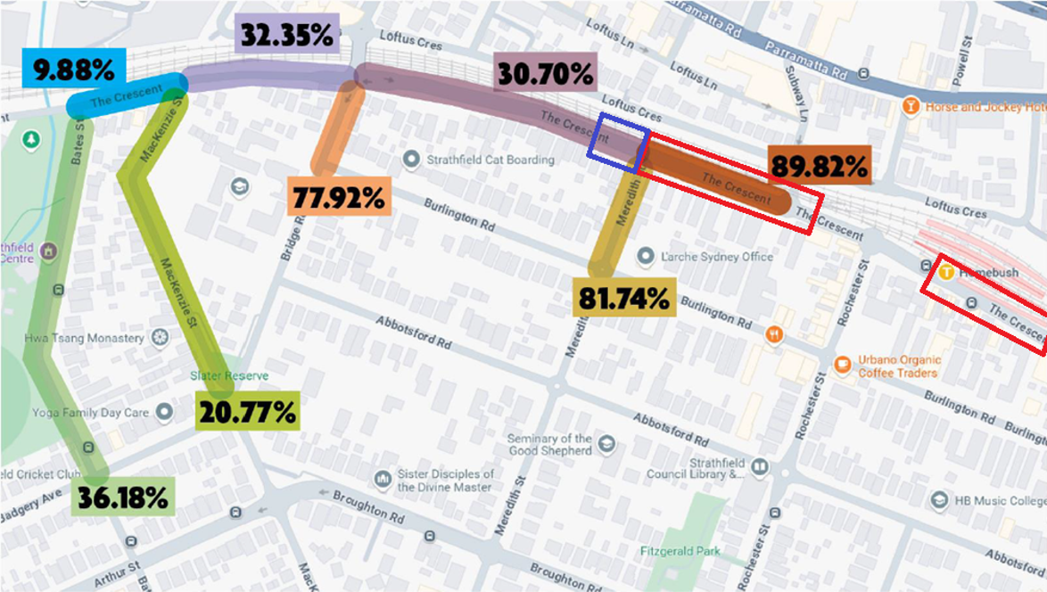
Parking rate percentages along The Crescent - Strathfield Council Parking Occupancy Study: The Crescent (August – September 2024) *Additional parking spaces retained west of Meredith Street (highlighted in blue):